Have you ever wanted to take an adventurous hike up to the mont Blanc via a beautiful route off the beaten path? If so, then come with us to Val Montjoie, along the ridge that links the Col de Tricot to the Aiguille de Bionnassay and continues up to the summit of the mont Blanc, the cherry on top to finish.
Greg, Seb and I left nice and early towards the Col de Tricot from the Miage chalets. This little warm-up got our legs ready for the ridge that followed. The route includes: the lower, central and upper Tricot peaks, then the Aiguille of Tricot 1500 metres [4921ft] higher, where we planned to bivouac.
")
Walking in the greenery of the Col de Tricot. ©Antoine Bouvier
")
The long ridge at the top of the summit of the Aiguille de Bionnassay. ©Antoine Bouvier
")
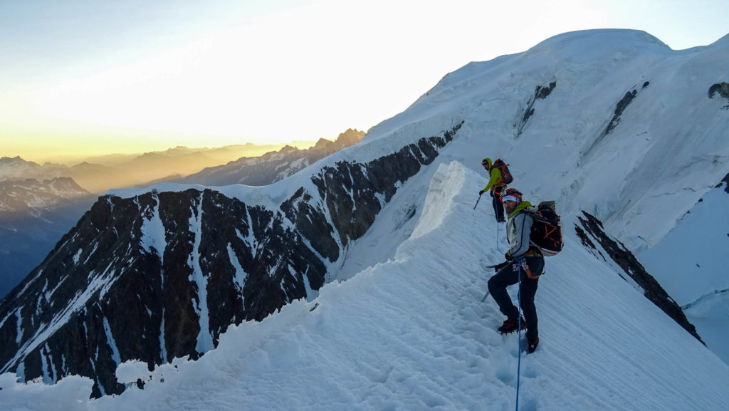
Seb climbing in front of the north face of the Dômes de Miage. ©Antoine Bouvier
")
Greg with the Dôme du Goûter in the background. ©Antoine Bouvier
")
The Glacier of Bionnassay below. ©Antoine Bouvier
We carefully tiptoed over unstable rock, with the sun beating on our backs. On our right, we could see the Glacier de Miage and the north face of the Dômes de Miage and on our left, the glacier of Bionnassay and the Aiguille du Goûter. The three Tricot peaks link together spectacularly. We then carefully climbed around two pinnacles of rock to reach the Brèche de Tricot.
At last, under the blazing sun and on sandy terrain, we reached the summit of the Aiguille de Tricot. Blessed with a large amount of snow and beautiful rocky platforms, we found a good spot to set up our bivouac.
")
Climbing down one of the pinnacles before the Brèche de Tricot. ©Antoine Bouvier

Cheers ! ©Antoine Bouvier
")
Seb overlooking the Vallée des Contamines. ©Antoine Bouvier
")
View of the Aravis mountain range. ©Antoine Bouvier
")
©Antoine Bouvier
")
Sunset on the Aiguille de Bionnassay. ©Antoine Bouvier
Starting early at 4am, we continued along the ridge, first on the snowy section, then on a rocky outcrop, before coming to the north face of the Aiguille de Bionnassay, which is partly made up of ice. With smiles on our faces and the sun beginning to rise, we made it to the summit of the Aiguille de Bionnassay (4052m [13,294ft]).
The route continues on the famous tapered ridge that runs down the Col of Bionnassay and then goes back up the Piton des Italiens. It’s long, exposed and one of the most impressive and majestic parts of the whole climb.
")
The valley awakens. ©Antoine Bouvier
")
Seb on the Aiguille de Bionnassay. ©Antoine Bouvier
The ascent of the Dôme du Goûter is still quite a climb and we tried not to overwork ourselves, especially at this altitude. From this point, there are two options : either descend by the normal mont Blanc route, or continue up to the summit, 500m above. We immediately decided to continue our adventure. We took a little break at the Vallot refuge to lighten our backpacks before taking on the traditional Arête des Bosses, and then after a final push, we headed towards the summit of the mont Blanc. As we got closer, we started to see a dome of snow and ice contrasting vividly with the green of the valley that we were greeted with the day before. It’s a wild and vibrantly colourful traverse. We made the most of the rare and intense moments of being at the summit, before heading back down via the normal route to the Nid d’Aigle, which we slowly followed towards the warmth and fervour of life below.
")
On the last stretch before the summit of Bionnassay ©Antoine Bouvier
")
The long traverse to the summit of the mont Blanc. ©Antoine Bouvier
")
Arriving at the Col du Dôme. ©Antoine Bouvier
")
On the Arête des Bosses ©Antoine Bouvier
")
Leaving the summit of the mont Blanc. ©Antoine Bouvier
")
The ridge taken with a view from the Refuge du Goûter. ©Antoine Bouvier
The Mont-Blanc Massif
Tricot – Bionnassay – mont-Blanc ridge
AD, 2 days of walking
Access :
Departure from the village of Bionnassay or the hamlet de la Gruvaz
Guidebook
Neige, glace et mixte, Tome 1, François Damilano, JMEditions
Equipment
30m single rope, straps, mountaineering gear for the glacier, and bivouac gear (snow present to make water at the top of the Aiguille de Tricot)
You follow a line of ridges in a wild setting. Climbers must be prepared for steep mountainous terrain. It’s a long route so make sure you pace yourself. The climb up to the summit of mont Blanc and back down is optional (a little bonus).